|
Scientists at Caltech's Tectonics Observatory (TO) are studying the mountain building process in the Himalayas, as well as the broader zone of crustal deformation in Central Asia (including Tibet and the Tian Shan area) that resulted from the collision between India and Eurasia (See Background Information).
TO scientists are working to answer questions such as:
- Where do the forces driving the collision between India and Eurasia come from?
- How do mountains form? What is the respective contribution of deformation due to earthquakes versus deformation due to ductile aseismic deformation?
- How does the feedback between erosion and mountain building really work and how influential is it on the way mountains form and evolve?
- What is the rheology (or flow of rocks under high pressure and temperature) of the continental crust and lithosphere?
- What is the risk of a large earthquake along the Himalayan front? How big? Where and when could it happen?
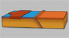
To address these questions, we are using GPS (Global Positioning System) geodesy to monitor both the the sudden deformation of Earth's crust that causes earthquakes as well as the slow, continual deformation occurring in between earthquakes (see Figure).
We are also mapping active faults and measuring slip rates on those faults using morphotectonic techniques (i.e., going to the faults, looking at the land formation, and relating it to tectonic events such as earthquakes) as well as modern dating techniques (such as optically stimulated luminescence and cosmogenic dating).
To study deformation over the longer term, we are analyzing the deep structure, deformation history, and exhumation history of the mountain ranges and fold systems in the area.
And finally, we are investigating how deformation in Central Asia relates to global plate tectonics using geodynamical modeling.
Learn more about current work:
Contact: Brian Wernicke
|
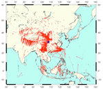
Velocity of the earth's surface, from GPS data - Note India's northeasterly motion. Blue star indicates the 2008 China earthquake
|
Research highlights
Video
|
|