Indo-Asian Collision Zone Project
Indo-Asian Home | People | Deformation | Data | Outreach | Publications | Links
Deformation in Tibet

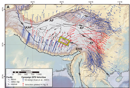
Fig. 1 Bird's eye view of Tibetan Plateau - The white area shows the Tibet Plateau. Each arrow corresponds to one GPS station, and shows the speed and direction of the land the GPS station sits on. The yellow box indicates the location of the fault we are studying, the Beng Co fault.
A closer look at the land in this box is shown in Figure 2.
|
While the theory of Plate Tectonics describes the Earth's outer layer as broken into many rigid pieces (tectonic plates), those plates themselves are not necessarily rigid; rather, they can undergo deformation.
From GPS measurements, scientists see that in Central Asia, the mountainous country of Tibet, shown in Figure 1, is stretching.
This leads to several questions:
-
Why is this area of the Eurasian Plate stretching?
- How fast is it stretching?
- Is the Tibetan Plateau acting like a continuously deforming material, much like a viscous fluid such as honey? If so, the plateau might best be described by what is called a "distributed model." (The distributed model provides a good description of continental deformation in the Basin and Range area of the western United States)
- Or is this region of the continent moving in a non-uniformly distributed way, where some areas move a lot and others just a little? If so, the plateau might better be described by a "block model." (The block model privides a good description of continental deformation in the Middle East)

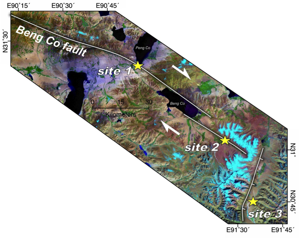
Fig. 2 Closer look at the portion of the Tibet Plateau where the "Beng Co" fault lies - The three yellow stars indicate the three sites where we measured slip rate.
|
One way to distinguish between these two mechanisms of continental deformation is to measure the slip rate along the major faults in the region. If the faults are all slipping at relatively slow rates everywhere (about 1 mm/year) then the distributed model is a good description. But if instead there are some faults that are slipping much faster, then the block model is the better description.
Although GPS stations can help us determine slip rate, the station coverage in Central Tibet is too sparse to determine slip rates there. Moreover, GPS can only offer slip rates averaged over the last 10 years (since there were no GPS stations before then). These 10-year averages may be different from the geological slip rates obtained by averaging over hundreds of thousands of years, which is what we want to know.
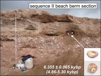
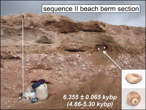
Fig. 3 Shells found in ancient beach ridge
|
To get averages over several thousands of years, we use the technique of Quaternary dating, where we determine the age of various geologic features (called geomorphic markers) that have been displaced by a fault. One example of a geomorphic marker is an ancient stream bed that runs across a fault. Because of the motion of the land along the fault, one side of the stream bed will be shifted, or offset, with respect to the other. If we know the age of the stream bed, and we measure the offset distance, we can calculate the speed at which the land is moving (speed = distance / time).
We made measurements at three sites on the Beng Co fault in Central Tibet (stars in Figure 2), for some sites using ancient stream beds, for others ancient beach ridges (see Figure 3). Taking all these measurements into account, we conclude that the most likely fault slip rate is 3 to 4 mm/year. This is in good agreement with the block model prediction for this fault, 4 mm/year, though in poor agreement with the continuous model's prediction of 1 mm/year. Thus we conclude that the eastward extrusion of Central Tibet is well described by localized, rather than distributed, slip on faults.
Work continues in the Tibetan Plateau. For most of the faults in this region, their slip rate awaits measurement.
Contacts: James Hollingsworth and Brian Wernicke
|