Central Andean Tectonic Observatory (CAnTO) Project
CAnTO Home | People | GPS/InSAR | PeruSE | Publications | Relevant Links
Peru Subduction Experiment (PeruSE)
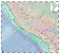
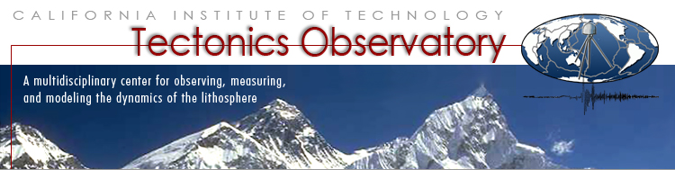
Figure 1. Seismometer arrays for the PeruSE project - Red dots denote Line 1, yellow dots Line 2, and light green dots Line 3. Purple squares along the coast denote the Coastal Line. Darker green dots denote the PULSE experiment of Wagner, Long and Beck; and black dots denote the CAUGHT experiment of Beck, Wagner, Zandt et al. Red triangles are active volcanoes, blue triangles are inactive. Thin black lines are slab contours. (Larger version) |
Scientific Motivation - Southern Peru is a natural laboratory to examine flat subduction because there are, in relatively close proximity, both normal and flat-slab subduction zones.
The generally assumed cause of the slab flattening is the subduction of the Nasca Ridge, which, rather than heading straight toward the trench (which it would have done had the subduction direction been perpendicular to the trench), has swept southward along the trench because the subduction direction is is slightly oblique. Over the past 5 million years, the Nasca Ridge has moved from Lima to its present location (shown in Figure 1).
The transition of the slab from flat to normal is seen to occur between Nasca and Arequipa; however, the nature of the transition is poorly known. The Nasca Ridge itself is not a large feature, and does not have sufficient (positive) buoyancy to be the sole force that “floats” the slab into its flattened position. It appears that it may be a catalyst for the flattening process, or that the process is non-linear.
This study seeks to uncover the mechanism that causes flattening.
The results for southern Peru will be compared to those obtained for central Mexico where there is a similar situation with flat-slab subduction adjacent to normal subduction. In the case of Mexico, there is nothing apparently impacting on the oceanic plate (such as a ridge, plateau, etc), and parameters derived from the seismic studies indicate that the flatten area is more hydrated than is the normal side.
Seismic Survey in Southern Peru -
We are in the process of running 3 dense seismic lines to explore the properties of the subduction system in each of the flat-slab and normal subduction regimes. The lines are shown in Figure 1, and their purpose and status are described below:
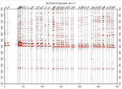
Figure 2. Recording of the December 8, 2010 Ecuador event (M 7.1) along Line1 - The zero position on the horizontal axis is the coast, and the 300 km position is Lake Titicaca
|
- Line 1: This line extends from the coast near Mollendo, goes through Arequipa to just north of Juliaca, near Lake Titicaca. The slab along this line exhibits “normal” subduction with a dip angle of 30 degrees. The line consists of 49 stations that span 300 km with an average station spacing of 6 km. Most parts of the line are interconnected with radio communications developed by the CENS project at UCLA. The line was deployed starting July, 2008 and continued in the full configuration until August, 2010 when the process of pulling every other station commenced. The recovered stations will be used on Line 3. An example of the data is shown in Figure 2.
- Line 2: This line extends from Juliaca to Cusco, a distance of 250 km. The line has 49 autonomous stations with an approximate spacing of 5 km. The line was initially deployed starting January 2010. The slab is at a depth of 250 km under the Juliaca end of the line and rises to just under 100 km depth at the Cusco end. The nature of the transition will provide an important constraint on the evolution of the slab flattening process. An example of the data is shown in Figure 3.
Figure 3. Recording of the December 8, 2010 Ecuador event along Line 2 The zero position on the horizontal axis is Lake Titicaca, and the 300 km position is Cusco.
|
- Line 3: The third extends from Cusco to the coast through Nazca. The seismicity indicates that the slab is flattened at a depth of approximately 100 km. We plane to deploy approximately 50 station along the line. The process of deploying the first 25 instruments (from Line 1) started in August, 2010, and should be operational by November, 2010. The next 25 instruments will be deployed in April-June, 2011 and will obtained from thinning Line 2.
- Coast Line: We are also planning to deploy 5-10 instruments borrowed from Jean-Paul Ampuero along the coast between Nasca and Arequipa. The purpose of these is instruments is to “complete” the 4th side of the box, allowing ambient noise correlation methods to be used to map the lateral variations in crustal and upper mantle properties within the box region. This is planned start November-December, 2010.
The PeruSE experiment is a collaborative project - between the Tectonics Observatory at Caltech and the Center for Embedded Network Sensors (CENS) at UCLA. Each group has contributed 50 seismic stations to the effort. The project also collaborates with the Institute of Geophysics, Peru (IGP) and the International Research and Development (France) in Peru (IRD-Peru).
|