Mexico is located on one of Earth's subduction zones, where the ocean floor of the Cocos tectonic plate is forcing its way down ("subducting") beneath the continental edge of the North American plate. Subduction zones are prone to large earthquakes, for the two plates grind against each other, sometimes sticking together ("locking"), the lower plate pulling the upper plate down with it and thus building up stress. When the stress builds to the breaking point, the upper plate breaks free and springs back to where it had been, thus lifting the ocean floor. This produces an earthquake and sometimes a tsunami (see animation). The lower plate moves slowly, only about 6 cm/year, about as fast as fingernails grow. Thus it takes hundreds of years for stress to build up before causing a large earthquake.
Subduction zones also often have a chain of volcanoes, called a volcanic arc. A volcanic arc is produced when the oceanic crust of the subducting plate attains high enough temperature and pressure to undergo metamorphism, releasing water which triggers melting of the mantle. (Much the same as when we sprinkle salt on icy pavement to melt the ice - the melting point of the ice/salt mixture is lower than that of pure ice.) The resulting magma then rises to the surface, spewing out as lava, and forming volcanoes.
Figure 1 shows Mexico and the neighboring ocean floor. The two tectonic plates meet off the southern shore of Mexico, forming a deep underwater trench parallel to the shoreline (dark blue line). This area is called the Middle American Subduction Zone.
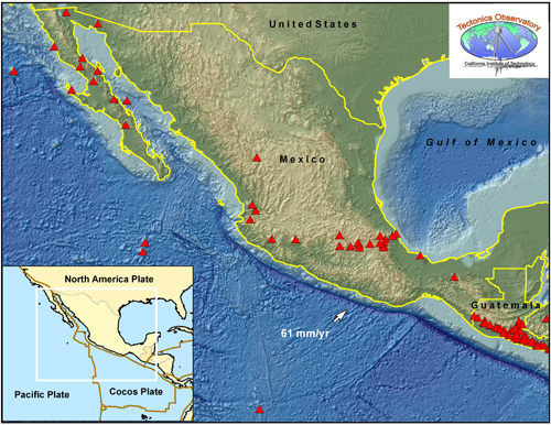
Figure 1. Deep trench off southern coast of Mexico. A map of the ocean floor reveals a deep underwater trench (dark blue line) running along the southern coast of Mexico, defining the boundary between two tectonic plates. The inset shows these plates to be the Cocos plate and the North American plate. Note that the dark blue line does not run further up the coast. There the Pacific plate and the North American plate are passing side-by-side. The San Andreas Fault is a well known example of this side-by-side type of motion, called strike-slip. The red triangles are volcanoes. Note how in Guatemala, the volcanoes run parallel to the trench, while in Southern Mexico they are further inland. Also indicated is the velocity of the subducting plate, 61mm/year. [Credit: Lisa Christiansen, TO]
Three unusual geological features can be seen in southern Mexico:
- First, in most subduction zones, large earthquakes occur at the interface between the two plates, at depths ranging from the earth's surface down to about 600 km. This region, called the "Benioff Zone", is used to locate the subducting plate, as shown for the case of Japan on the left-hand side of Figure 2. However, in southern Mexico, few earthquakes are seen below 100 km in depth (see right-hand side of Figure 2).
Figure 2. Distribution of strong earthquakes for two subduction zones. For Japan (upper left), the depth distribution of strong earthquakes reveals the plate interface (lower left). [Note that the line from A to A' in the upper plot runs from right to left, while in the lower plot it runs from left to right.] In contrast, for southern Mexico (upper right), there are few strong earthquakes below 150 km in depth, leaving us with the question of where is the subducting plate (lower right)? [Seismicity from NEIC-USGS; Credit: Anthony Sladen, TO]
- Second, in most subduction zones, there is an inland volcanic arc running parallel to the trench. But in southern Mexico, the volcanic arc bends away from the trench, at about a 15° angle (see Figure 1).
- Finally, in most subduction zones, giant earthquakes occur every few hundred years or so. Such earthquakes do occur in southern Mexico as well (e.g., the Michoacan, Mexico earthquake of magnitude 8.0 in 1985), but only close to the coast. Moreover, recently another form of earthquake has been discovered here, called a "silent earthquake" (or a slow slip event). These occur so slowly that a single "earthquake" can last as long as a month, and the seismic waves they produce, called tremors, are so weak that we cannot feel them.
These three features are poorly understood. Scientists from Caltech's Tectonics Observatory (TO) hope that their study, called the MesoAmerican Subduction Experiment (MASE), will have important implications beyond Mexico. For example, why are the great plains of the western United States so high? (e.g., Why is Denver the "mile-high city"?) Scientists believe that understanding the subduction process in southern Mexico may shed light on how the western United States came to be.
A better understanding of silent earthquakes and tremors may eventually lead to better seismic hazard assessment. It is not yet clear whether there is any relation between the giant earthquakes of subduction zones and silent earthquakes. Do the silent earthquakes relieve strain and thus lessen seismic hazard, or, by relieving strain in one area, do they cause strain to build up elsewhere and thus increase seismic hazard? This is an active area of research.
I. Where is the subducting plate?
The Mexican subduction zone lacks the typical "Benioff Zone" of seismicity, which helps delineate the subducting slab in most subduction zones around the world (Figure 2). To get around this problem, TO scientists search for the slab using a different method of analyzing seismic data, which is based on Receiver Function Analysis. This method locates interfaces below the surface of the earth (such as the crust/mantle boundary) by detecting the effect of the interface on the seismic waves. For example, the crust/mantle boundary can change a P wave into an S wave. As a result, Receiver Function Analysis provides an image of the subducting slab below the seismometers.
Since this technique requires a dense array of seismic stations, TO scientists installed 100 seismometers in a line across Mexico (Figure 3). The line, called the MASE array, extends from Acapulco on the Pacific coast, through Mexico City, almost to Tempico on the Gulf of Mexico. (See installation of a seismometer)
Figure 3. Dense line of 100 broad-band seismometers called the MASE (MesoAmerican Subduction Experiment) array. This array (red points), with seismometers spaced 5 km apart, crosses Mexico. It was installed in 2005. The contour lines show the depth of the subducting slab. [Modified from Chen and Clayton, JGR 2009]
What TO scientists discovered from the analysis of the MASE seismic data surprised everyone. The high-resolution image of the subducting slab underneath Mexico (Figure 4) shows the slab to be so shallow that it is actually lying flat against the continental crust above it. And it stays this way, nearly horizontal, for 250 km, nearly all the way to Mexico City. This is very unusual. It is given the name "flat slab subduction."
Receiver Function Analysis of the MASE seismic data is shown in Figure 4, which shows a side view of the line of MASE seismometers (black triangles). On the left is Acapulco, in the middle Mexico City and the volcanic belt, and on the right is the city of Tempoal. The height of the triangles shows the topography of the land. Extending down below the seismometers is a vertical cross section of the Earth below; the colors correspond to Receiver Function amplitudes. While these receiver functions can be difficult to decipher for the untrained eye, the inset at the bottom left shows an enlarged view of one area for one seismic event. The dark blue ribbon represents the position of the subduction slab, showing the shallow angle below Acapulco and subsequent flattening out.
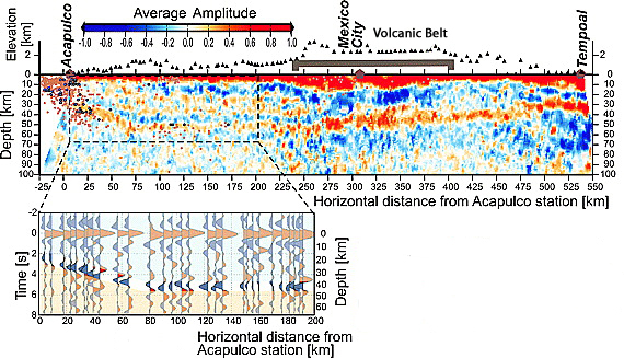
Figure 4. High-Resolution Image of Subducting Slab "Hugging" the Crust Above. The MASE seismometers (black triangles) run along the top line at the Earth's surface. Their heights show the topography of the terrain. The volcanic arc is seen to lie further inland than expected for a subduction zone. The Receiver Functions below each station reveal the position of the subducting slab. The inset at the bottom left shows a blow-up of the flat slab region. The slab position is shown by the darker blue signal. The light blue area above is continental crust, the light orange area below is mantle. The slab lies right up against the crust. [Modified from Perez-Campos et al., GRL 2008]
To see at even greater depths below the earth's surface, TO scientists use another method of seismic data analysis, Seismic Tomography. Though lower in resolution than Receiver Function Analysis, Seismic Tomography can "see" down to 700 km, well into the mantle. This method detects changes in seismic wave velocity due to changes in the earth's density. Waves speed up when passing through denser rock; they slow down when passing through less dense rock. Since the subducting slab is more dense than the surrounding mantle, its position can be determined. (Learn more about Seismic Tomography)
Figure 5 shows the full image of the subducting slab, obtained by combining the results of both Receiver Function Analysis and Seismic Tomography. The slab begins forcing its way down beneath the continental crust at a shallow angle, then levels off to nearly horizontal. Below Mexico City it plunges steeply into the mantle and ends abruptly at a depth of about 500 km. Scientists suspect that this abrupt termination of the plate may be due to an earlier tear at that location, before that portion of the ocean floor had subducted.
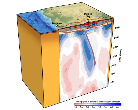
Figure 5. Full Image of Subducting Slab. This image is similar to that in Figure 4, but goes down to greater depth. The purple line shows the whole subducting slab as it takes a shallow dive below Acapulco, levels out almost to Mexico City, then dives more steeply into the mantle, and finally abruptly breaks off at about 500 km depth. The contour lines indicate wave speed. Blue lines show where seismic waves traveled faster, indicating the area is dense (hence is the slab). Pink lines show where waves traveled slower, indicating the area is less dense (hence is the mantle). [From Perez-Campos et al., GRL 2008]
II. Why does the volcanic arc veer inland?
In subduction zones, volcanoes are formed when hydrated minerals in the subducting plate undergo metamorphism and release water (dehydration). This water seeps into the mantle, causing patches of the mantle to melt at lower temperatures than usual. The resulting magma rises to the surface and spews violently out as lava, forming a volcano. This dehydration process requires very high temperature and pressure, and usually occurs when the slab reaches about 100 km in depth. Thus when we see volcanoes near subduction zones, we know that directly below them, at about 100 km in depth, lies what used to be the ocean floor.
For most subduction zones, the subducting plate reaches 100 km in depth at about 100 km inland from the trench. Hence most volcanic arcs are located 100 km from the trench. But in southern Mexico, because the subducting slab flattens out, it does not reach 100 km in depth until about 300 km from the trench, thus forming volcanoes 300 km from the trench. Since this flat slab region is bounded on both sides by normal subduction zones, the volcanic arc bends inland in this region.
III. How did this unusual slab come to be?
What were the conditions that caused this subducting slab to flatten out? And what then caused it to end abruptly at 500 km depth? To answer such questions, TO scientists are developing numerical models to simulate the forces inside the earth over the last 22 million years. With these models, they are able to predict the evolution of normal subduction changing into flat subduction over this time span.
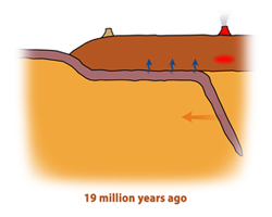
Animation: evolution of flat subduction
They find that 30 million years ago there had been normal subduction here, with active volcanoes along the Pacific coast. But about 22 million years ago those volcanoes shut off because the subduction went horizontal. New volcanoes started to erupt, on the Gulf coast, indicating that the flat slab extended nearly all the way to that coast. Since then, the line of active volcanoes has been rolling back toward the Pacific coast, as the extent of the slab has been decreasing.
This 22-million-year march of the volcanoes from the Gulf coast back toward the Pacific coast is the cause of the high elevation of Mexico City, which sits on the remnants of old volcanoes.
One way such a change from normal to flat subduction could have occurred is if there had been a layer of low-viscosity (easily flowing) material right below the crust, which then gave way as the subducting slab pressed against it from below. One possible source of a low-viscosity mantle layer could be the release of water by the subducting plate as it reaches high pressures and temperatures, as discussed in the previous section. The model results (Figure 6) predict a slab geometry similar to that obtained by the seismic data (Figure 5).
Figure 6. Computer Model of the Evolution of Flat-Slab Subduction. By having a low-viscosity mantle wedge (red in panel on left-hand side) just below the crust, the subducting plate can flatten as it squeezes that material out of the way. [Modified from Perez-Campos et al., GRL 2008]
IV. Tremors and slow, silent earthquakes
Another unusual aspect about the Mexican subduction zone is the occurrence of silent earthquakes (aseismic slip events) that are so slow that we cannot feel them. In fact, these slow slip events are only visible in continuous GPS (Global Positioning System) time series measurements, which show the position of a GPS station on the continental crust of the upper plate (yellow points in Figure 7) as a function of time.
Figure 7. Continuous GPS signals showing slow slip events, and their relation to tremors Both GPS data (yellow) showing slow slip, and seismic data (red and green) showing tremors, are plotted on the same graph. The GPS data shows two silent earthquakes, in early 2002 and mid-2006. The clustering of tremors during these two events (circled areas) confirms that slow slip is one cause of the tremor. [Modified from Payero et al., GRL 2008]
The gradual motion of the GPS station landward, away from the trench (the rise of the yellow line) is due to the upper plate being "stuck" to the subducting plate beneath, and thus being squeezed along with it. The reversal of the direction of the GPS station, back toward the sea (the fall of the yellow line), indicates that the upper plate has become partially unstuck, and is slipping back toward the trench. In most subduction zones, it snaps back in a matter of seconds, causing a large earthquake. But here it takes months to slip back. These slow slip events amount to about 2 to 4 cm of displacement, and recur about every 5 years.
We cannot feel these slow slip events. Seismometers cannot even detect them, at least not directly. It was only by comparing seismographs from different instruments, using the technique of cross correlation (or looking for patterns in the signals) that TO scientists detected the weak seismic signals, called tremors, and located their sources (called hypocenters). Such an analysis is shown in Figure 8. Panel A shows the weak signals on the left. The blue arrows on the right show that the seismometers are picking up the same nearly imperceptible signals, though at different times. Panel B shows that the sources of the seismic signals (red and yellow stars) occur mainly at and above the plate boundary, indicating that stress in the upper plate causes the tremors.
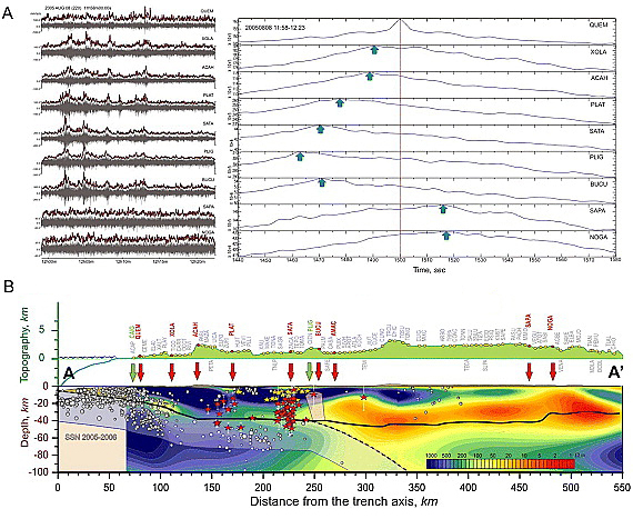
Figure 8. Detection of tremors and location of their sources Panel A shows very weak signals, called tremors, from nine of the MASE seismometers (left-hand side) and cross correlation functions between those signals (right-hand side). The blue arrows show the times that different stations detected the same nearly imperceptible seismic wave. Panel B shows the same line of MASE seismometers as in Figure 4, with the name of each above it, and the topography of the land. The hyocenter, or sources, of the tremors are shown by the red and yellow stars. The boundary between the two tectonics plates is shown by the dashed line, and the subducting slab by the hazy blue "ribbon." [Modified from Payero et al., GRL 2008]
The frequency of these tremors is compared with the GPS signal in Figure 7. Two time periods, early 2002 and mid-2006, show heightened seismic activity, as indicated by the density of green and red lines. These times correlate with slow slip events detected by the GPS signal (yellow). Thus thanks to the MASE seismic data, we now know that these slow slip events are accompanied by swarms of seismic activity called tremors. Tremors have been detected in other subduction zones (Japan, Cascadia) and their origin remains poorly understood.
Scientists think that tremors may be produced by fluids circulating in the highly strained and deformed medium of the subducting plate. A detailed analysis of seismic waves crossing the interface between the subducting and overlying plates has revealed the existence of an anomalous thin layer, sandwiched in between the two plates. This layer slows some types of seismic waves down by as much as 30% to 50%, and so is called the Ultra-Slow velocity Layer (USL). Scientists have found that this layer coincides with the locations of slow earthquakes, as shown schematically in Figure 9, and that adjacent to these regions lie the hypocenters of tremor.
Figure 9. Schematic cross section comparing different measurements. The slab geometry is shown in comparison with the location of large earthquakes, silent earthquakes, tremor, ultra-slow velocity layer (USL), and temperature [Modified from Song et al., Science 2009]
What are some implications of this study?
By studying this unusual, flat-slab subduction zone, TO scientists are gaining insight into the workings of subduction zones in general, and into the history of flat subduction zones in particular. These insights may help unravel the history of subduction zones that have occurred long ago.
One example of this is the Farallon plate, believed to have subducted under the western continental United States several hundreds of millions of years ago. Like the blade of a shovel gliding into the ground at a steep angle, the diving slab in normal subduction zones does not usually affect the level of the ground above it. But when we push down on the handle of the shovel, thus lifting and flattening out the blade, the ground above it lifts up. Similarly, the slab's flattening may have raised the great plains of the continental United States from sea level to their current mile-high elevation. Moreover, that flat subduction zone may also have been responsible for moving the coastal volcanoes inland, all the way to Kansas. Thus understanding the current flat slab subduction in Mexico may shed light on how the western United States came to be.
TO scientists also hope that measurements of tremor, besides providing a window into the dynamics of subduction zones and the events that lead to major earthquakes, may someday improve earthquake hazard assessment. For example, if it is shown that an increase in tremor precedes giant earthquakes, this may one day provide some advance warning.
References
Chen, T., and R. W. Clayton (2009), Seismic attenuation structure in central Mexico: Image of a focused high-attenuation zone in the mantle wedge, J. Geophys. Res., 114, B07304, doi:10.1029/2008JB005964 (pdf)
Song, T-R.A., Helmberger, D.V., Brudzinski, M.R., Clayton, R.W., Davis, P., Perez-Campos, X., Singh. S.K., Subducting Slab Ultra-Slow Velocity Layer Coincident with Silent Earthquakes in Southern Mexico. Science 24 April 2009: 502-506, DOI: 10.1126/science.1167595 (2009) (pdf)
Perez-Campos, X., Y. Kim, A. Husker, P. M. Davis, R. W. Clayton, A. Iglesias, J. F. Pacheco, S. K. Singh, V. C. Manea, and M. Gurnis (2008), Horizontal subduction and truncation of the Cocos Plate beneath central Mexico, Geophys. Res. Lett., 35, L18303, doi:10.1029/2008GL035127 (pdf)
Payero, J. S., V. Kostoglodov, N. Shapiro, T. Mikumo, A. Iglesias, X. Perez-Campos, and R. W. Clayton (2008), Nonvolcanic tremor observed in the Mexican subduction zone, Geophys. Res. Lett., 35, L07305, doi:10.1029/2007GL032877 (pdf)
Last modified May 14, 2009
Email: outreach (at) tectonics.caltech.edu
PDF file for printing: coming soon

